
Doe een donatie
Rust jezelf uit voor je volgende avontuur:
Als Amazon-partner verdient deze site een commissie op in aanmerking komende aankopen, zonder extra kosten voor jou.
Topografische kaart Wachau Cultural Landscape
Klik op de kaart om de hoogte weer te geven.
Doe een donatie
Rust jezelf uit voor je volgende avontuur:
Als Amazon-partner verdient deze site een commissie op in aanmerking komende aankopen, zonder extra kosten voor jou.
Wachau Cultural Landscape
The Danube valley in Austria between the cities of Melk and Krems in Lower Austria is called the Wachau. This stretch of the valley includes the hills and the adjacent Dunkelsteiner Wald (Dunkelsteiner Forest) and the southern Waldviertel. The Danube river flows north-northeast from Melk to Dürnstein through a meander from which it flows southeast, then east past the city of Krems. In the Wachau, the town of Spitz lies on the Danube's western bank and the city of Melk on its eastern bank. Other important towns in the valley are Dürnstein, Weißenkirchen in der Wachau and Emmersdorf an der Donau, which have a galaxy of old homestead buildings dating from the mid-6th century. The railway line built in 1909 between Krems and Emmersdorf is a topographical marvel. Other settlements of note in the Wachau valley include Aggsbach, Bachamsdorf, Bergern im Dunkelsteinerwald, Furth bei Göttweig, Joching, Maria Laach am Jauerling, Mautern an der Donau, Mühldorf, Oberamsdorf, Oberloiben, Rossatz-Arnsdorf, Ruhrsdorf, Schwallenbach, Schönbühel-Aggsbach, Unterloiben and Willendorf.
Doe een donatie
Rust jezelf uit voor je volgende avontuur:
Als Amazon-partner verdient deze site een commissie op in aanmerking komende aankopen, zonder extra kosten voor jou.
Over deze kaart
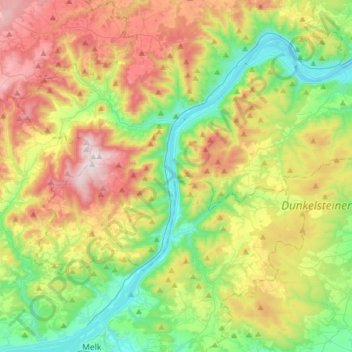
Naam: Topografische kaart Wachau Cultural Landscape, hoogte, reliëf.
Gemiddelde hoogte: 486 m
Minimale hoogte: 189 m
Maximale hoogte: 961 m
Doe een donatie
Rust jezelf uit voor je volgende avontuur:
Als Amazon-partner verdient deze site een commissie op in aanmerking komende aankopen, zonder extra kosten voor jou.
Andere topografische kaarten
Klik op een kaart om zijn topografie, zijn hoogte en zijn reliëf te bekijken.
Doe een donatie
Rust jezelf uit voor je volgende avontuur:
Als Amazon-partner verdient deze site een commissie op in aanmerking komende aankopen, zonder extra kosten voor jou.
Loiwein
Austria > Lower Austria > Bezirk Krems > Gemeinde Lichtenau im Waldviertel
Gemiddelde hoogte: 552 m