
Topografische kaart Clark County
Interactieve kaart
Klik op de kaart om de hoogte weer te geven.
Over deze kaart
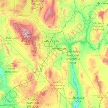
Naam: Topografische kaart Clark County, hoogte, reliëf.
Locatie: Clark County, Nevada, United States (35.00189 -115.89535 36.85409 -114.04629)
Gemiddelde hoogte: 968 m
Minimale hoogte: 149 m
Maximale hoogte: 3.536 m
The Colorado River forms the county's southeastern boundary, with Hoover Dam forming Lake Mead along much of its length. The lowest point in the state of Nevada is on the Colorado River just south of Laughlin in Clark County, where it flows out of Nevada into California and Arizona. Greater Las Vegas is a tectonic valley, surrounded by four mountain ranges, with nearby Mount Charleston being the highest elevation at 11,918 ft (3,633 m), located to the northwest. Other than the forests on Mount Charleston, the geography in Clark County is a desert. Creosote bushes are the main native vegetation, and the mountains are mostly rocky with little vegetation. The terrain slopes to the south and east. The county has an area of 8,061 square miles (20,880 km2), of which 7,891 square miles (20,440 km2) is land and 169 square miles (440 km2) (2.1%) is water.
Andere topografische kaarten
Klik op een kaart om zijn topografie, zijn hoogte en zijn reliëf te bekijken.
Henderson
United States > Nevada > Clark County
Henderson, Clark County, Nevada, United States
Gemiddelde hoogte: 691 m
Orovada
United States > Nevada > Humboldt County
Orovada, Humboldt County, Nevada, 89425, United States
Gemiddelde hoogte: 1.352 m
Clock Spring
United States > Nevada > White Pine County
Clock Spring, Gleason Creek Road, White Pine County, Nevada, United States
Gemiddelde hoogte: 2.522 m
Nelson
United States > Nevada > Clark County
Nelson, Clark County, Nevada, United States
Gemiddelde hoogte: 978 m
Searchlight
United States > Nevada > Clark County
Searchlight, Clark County, Nevada, 89046, United States
Gemiddelde hoogte: 1.088 m
Moapa Valley
United States > Nevada > Clark County
Moapa Valley, Clark County, Nevada, 89021, United States
Gemiddelde hoogte: 520 m
Mount Charleston
United States > Nevada > Clark County
Mount Charleston, Clark County, Nevada, United States
Gemiddelde hoogte: 2.560 m
Smith Peak
United States > Nevada > Elko County
Smith Peak, Elko County, Nevada, United States
Gemiddelde hoogte: 2.943 m
Cold Springs
United States > Nevada > Washoe County
Cold Springs, Washoe County, Nevada, 89508, United States
Gemiddelde hoogte: 1.573 m
Lake Mead
United States > Nevada > Clark County
Lake Mead, Clark County, Nevada, United States
Gemiddelde hoogte: 684 m
Nixon
United States > Nevada > Washoe County
Nixon, Washoe County, Nevada, 89424, United States
Gemiddelde hoogte: 1.209 m
Sandy Valley
United States > Nevada > Clark County
Sandy Valley, Clark County, Nevada, United States
Gemiddelde hoogte: 998 m
Dixie Valley
United States > Nevada > Churchill County
Dixie Valley, Churchill County, Nevada, United States
Gemiddelde hoogte: 1.046 m
McDermitt
United States > Nevada > Humboldt County
McDermitt, Humboldt County, Nevada, 89421, United States
Gemiddelde hoogte: 1.359 m
Las Vegas
United States > Nevada > Clark County
Las Vegas, Clark County, Nevada, United States
Gemiddelde hoogte: 756 m
San Jacinto
United States > Nevada > Elko County
San Jacinto, Elko County, Nevada, United States
Gemiddelde hoogte: 1.603 m
Winchester
United States > Nevada > Clark County
Winchester, Clark County, Nevada, United States
Gemiddelde hoogte: 586 m
Austin
United States > Nevada > Lander County
Austin, Lander County, Nevada, United States
Gemiddelde hoogte: 2.076 m
Incline Village-Crystal Bay
United States > Nevada > Washoe County
Incline Village-Crystal Bay, Washoe County, Nevada, United States
Gemiddelde hoogte: 2.173 m
Reno
United States > Nevada > Washoe County
Reno, Washoe County, Nevada, United States
Gemiddelde hoogte: 1.650 m
Great Basin National Park
United States > Nevada > White Pine County
Great Basin National Park, White Pine County, Nevada, United States
Gemiddelde hoogte: 2.352 m
Desert
United States > Nevada > Churchill County > Fernley
Desert, Fernley, Churchill County, Nevada, United States
Gemiddelde hoogte: 1.247 m
North Las Vegas
United States > Nevada > Clark County
North Las Vegas, Clark County, Nevada, United States
Gemiddelde hoogte: 684 m
Walker Lake
United States > Nevada > Mineral County > Schurz
Walker Lake, Schurz, Mineral County, Nevada, United States
Gemiddelde hoogte: 1.531 m
Sonoma Valley
United States > Nevada > Humboldt County
Sonoma Valley, Humboldt County, Nevada, United States
Gemiddelde hoogte: 2.052 m
Steptoe Valley
United States > Nevada > White Pine County
Steptoe Valley, White Pine County, Nevada, United States
Gemiddelde hoogte: 2.142 m
Summerlin South
United States > Nevada > Clark County
Summerlin South, Clark County, Nevada, United States
Gemiddelde hoogte: 935 m
Tonopah
United States > Nevada > Nye County
Tonopah, Nye County, Nevada, United States
Gemiddelde hoogte: 1.842 m
Great Basin
United States > Nevada > Eureka County
Great Basin, Eureka County, Nevada, United States
Gemiddelde hoogte: 1.918 m
Delano Peak
United States > Nevada > Elko County
Delano Peak, Elko County, Nevada, United States
Gemiddelde hoogte: 2.192 m
Sparks
United States > Nevada > Washoe County
Sparks, Washoe County, Nevada, United States
Gemiddelde hoogte: 1.438 m
North Las Vegas
United States > Nevada > Clark County > North Las Vegas
North Las Vegas, Clark County, Nevada, 89030, United States
Gemiddelde hoogte: 677 m
Genoa
United States > Nevada > Douglas County > Genoa
Genoa, Douglas County, Nevada, 89411, United States
Gemiddelde hoogte: 1.687 m
Lake Las Vegas
United States > Nevada > Clark County > Henderson > Lake Las Vegas
Lake Las Vegas, Henderson, Clark County, Nevada, United States
Gemiddelde hoogte: 455 m
Pahrump
United States > Nevada > Nye County
Pahrump, Nye County, Nevada, United States
Gemiddelde hoogte: 1.141 m
Summit Mountain
United States > Nevada > Eureka County
Summit Mountain, Eureka County, Nevada, United States
Gemiddelde hoogte: 2.847 m
McGill
United States > Nevada > White Pine County > McGill
McGill, White Pine County, Nevada, 89318, United States
Gemiddelde hoogte: 1.973 m
Lamoille
United States > Nevada > Elko County > Lamoille
Lamoille, Elko County, Nevada, 89828, United States
Gemiddelde hoogte: 1.799 m
Whitney
United States > Nevada > Clark County
Whitney, Clark County, Nevada, 89112, United States
Gemiddelde hoogte: 524 m
Carson City
United States > Nevada > Carson City
Carson City, Nevada, 89701-4763, United States
Gemiddelde hoogte: 1.819 m
White Pine County
White Pine County, Nevada, United States
Gemiddelde hoogte: 2.049 m
Henderson
United States > Nevada > Clark County > Henderson
Henderson, Clark County, Nevada, 89009-0625, United States
Gemiddelde hoogte: 662 m
Cal-Nev-Ari
United States > Nevada > Clark County > Cal-Nev-Ari
Cal-Nev-Ari, Clark County, Nevada, United States
Gemiddelde hoogte: 780 m
Winnemucca
United States > Nevada > Humboldt County > Winnemucca > Winnemucca
Winnemucca, Humboldt County, Nevada, 89445, United States
Gemiddelde hoogte: 1.403 m