
Topografische kaart Fouday
Interactieve kaart
Klik op de kaart om de hoogte weer te geven.
Over deze kaart
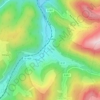
Naam: Topografische kaart Fouday, hoogte, reliëf.
Gemiddelde hoogte: 519 m
Minimale hoogte: 373 m
Maximale hoogte: 725 m
The village is served by the National Road (Route nationale) 420 which connects Strasbourg with Saint-Dié. The town is also traversed by the railway line - here just a single track - that connects these two urban centres. The mountain topography of the region keeps the road and railway running in close parallel along the Bruche Valley.