
Topografische kaart Plentzia
Interactieve kaart
Klik op de kaart om de hoogte weer te geven.
Over deze kaart
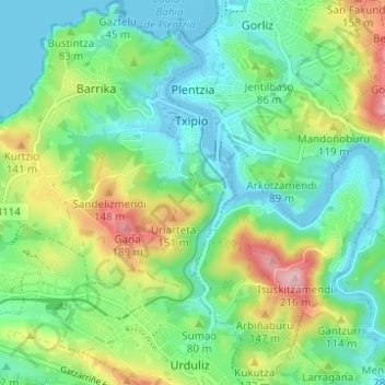
Naam: Topografische kaart Plentzia, hoogte, reliëf.
Gemiddelde hoogte: 61 m
Minimale hoogte: -5 m
Maximale hoogte: 200 m
Andere topografische kaarten
Klik op een kaart om zijn topografie, zijn hoogte en zijn reliëf te bekijken.
Getxo
Spain > Autonomous Community of the Basque Country > Andraka
Getxo, Andraka, Biscay, Autonomous Community of the Basque Country, 48620, Spain
Gemiddelde hoogte: 36 m
Mungia
Spain > Autonomous Community of the Basque Country > Andraka
Mungia, Andraka, Biscay, Autonomous Community of the Basque Country, 48620, Spain
Gemiddelde hoogte: 111 m
Loiu
Spain > Autonomous Community of the Basque Country > Andraka
Loiu, Andraka, Biscay, Autonomous Community of the Basque Country, 48620, Spain
Gemiddelde hoogte: 70 m
Urduliz
Spain > Autonomous Community of the Basque Country > Andraka
Urduliz, Andraka, Biscay, Autonomous Community of the Basque Country, 48620, Spain
Gemiddelde hoogte: 90 m