
Topografische kaart Hakuba
Interactieve kaart
Klik op de kaart om de hoogte weer te geven.
Hakuba
The village has humid continental climate (Köppen Dfa), with cold, extremely snowy winters, and warm, rainy summers. With temperatures cooled by the elevation, monthly 24-hour average temperature ranges from −2.8 °C (27.0 °F) in January to 22.6 °C (72.7 °F) in July. Hakuba receives approximately 11 meters of snowfall annually, with most snowfall occurring in the months of January and February.
Over deze kaart
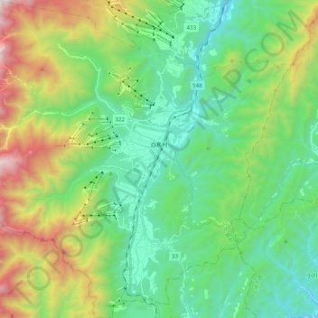
Naam: Topografische kaart Hakuba, hoogte, reliëf.
Locatie: Hakuba, Kita-Azumi County, Nagano Prefecture, Japan (36.61393 137.75002 36.76769 137.94154)
Gemiddelde hoogte: 1.120 m
Minimale hoogte: 528 m
Maximale hoogte: 2.578 m
Andere topografische kaarten
Klik op een kaart om zijn topografie, zijn hoogte en zijn reliëf te bekijken.