
Topografische kaart Scoudouc
Interactieve kaart
Klik op de kaart om de hoogte weer te geven.
Over deze kaart
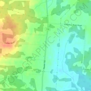
Naam: Topografische kaart Scoudouc, hoogte, reliëf.
Gemiddelde hoogte: 32 m
Minimale hoogte: 15 m
Maximale hoogte: 59 m
Andere topografische kaarten
Klik op een kaart om zijn topografie, zijn hoogte en zijn reliëf te bekijken.
Sackville
Canada > New Brunswick > Westmorland County > Sackville
Sackville, Sackville Parish, Westmorland County, New Brunswick, Canada
Gemiddelde hoogte: 31 m
Beaubassin East
Canada > New Brunswick > Westmorland County > Beaubassin East
Beaubassin East, Shediac Parish, Westmorland County, New Brunswick, Canada
Gemiddelde hoogte: 22 m
Breau Creek
Canada > New Brunswick > Westmorland County > Memramcook
Breau Creek, Memramcook, Dorchester Parish, Westmorland County, New Brunswick, Canada
Gemiddelde hoogte: 64 m
Dieppe
Canada > New Brunswick > Westmorland County > Dieppe
Dieppe, Moncton Parish, Westmorland County, New Brunswick, E1A 1G9, Canada
Gemiddelde hoogte: 58 m
Haute-Aboujagane
Canada > New Brunswick > Westmorland County > Beaubassin East
Haute-Aboujagane, Beaubassin East, Shediac Parish, Westmorland County, New Brunswick, Canada
Gemiddelde hoogte: 28 m
Johnson's Mills
Canada > New Brunswick > Westmorland County > Johnson's Mills
Johnson's Mills, Sackville Parish, Westmorland County, New Brunswick, Canada
Gemiddelde hoogte: 24 m
New Scotland
Canada > New Brunswick > Westmorland County
New Scotland, Moncton Parish, Westmorland County, New Brunswick, Canada
Gemiddelde hoogte: 85 m