
Doe een donatie
Rust jezelf uit voor je volgende avontuur:
Als Amazon-partner verdient deze site een commissie op in aanmerking komende aankopen, zonder extra kosten voor jou.
Topografische kaart Bella Coola
Klik op de kaart om de hoogte weer te geven.
Doe een donatie
Rust jezelf uit voor je volgende avontuur:
Als Amazon-partner verdient deze site een commissie op in aanmerking komende aankopen, zonder extra kosten voor jou.
Bella Coola
There is a 454 km mostly paved road connection by Highway 20 to Williams Lake. The road was built in 1953 by local residents, and features a 15 km ascent from the Valley floor to the Chilcotin plateau, gaining 1600m in elevation to the summit at Heckman Pass, via a number of steep grades & switchbacks. The construction of this road was described in the books "Bella Coola" and "A Road Runs West".
Doe een donatie
Rust jezelf uit voor je volgende avontuur:
Als Amazon-partner verdient deze site een commissie op in aanmerking komende aankopen, zonder extra kosten voor jou.
Over deze kaart
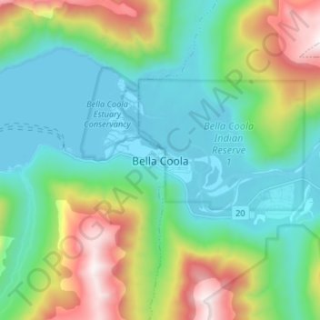
Naam: Topografische kaart Bella Coola, hoogte, reliëf.
Gemiddelde hoogte: 438 m
Minimale hoogte: -1 m
Maximale hoogte: 1.609 m
Doe een donatie
Rust jezelf uit voor je volgende avontuur:
Als Amazon-partner verdient deze site een commissie op in aanmerking komende aankopen, zonder extra kosten voor jou.