
Topografische kaart Nirmal
Interactieve kaart
Klik op de kaart om de hoogte weer te geven.
Nirmal
Nirmal is located at 19°06′N 78°21′E / 19.10°N 78.35°E / 19.10; 78.35. It has an average elevation of 340 metres (1100 feet) on the foot hills of Nirmal range, which is located in the Deccan plateau.Nirmal has chain tanks built around it.
Over deze kaart
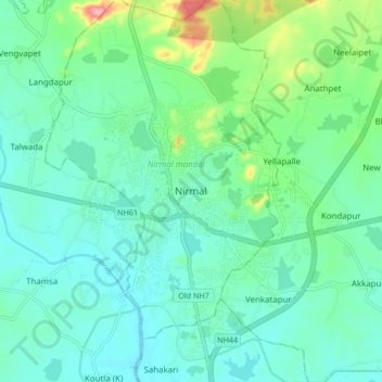
Naam: Topografische kaart Nirmal, hoogte, reliëf.
Gemiddelde hoogte: 335 m
Minimale hoogte: 310 m
Maximale hoogte: 424 m