
Topografische kaart Town of Danby
Interactieve kaart
Klik op de kaart om de hoogte weer te geven.
Over deze kaart
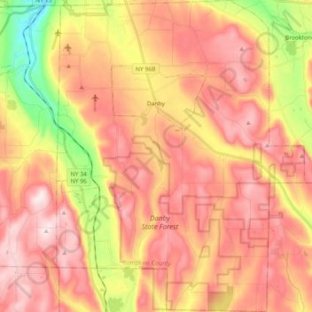
Naam: Topografische kaart Town of Danby, hoogte, reliëf.
Locatie: Town of Danby, Tompkins County, New York, United States (42.26275 -76.53851 42.39654 -76.39437)
Gemiddelde hoogte: 404 m
Minimale hoogte: 134 m
Maximale hoogte: 586 m
Elevations range from approximately 450 feet above sea level where Cayuga Inlet crosses the northern town line, to about 1230 feet at Town Hall in Danby Hamlet, to just over 1800 feet at Dawes Hill in the southwestern part of the town and Roundtop in the southeastern part of the town. The dramatic hill and valley lands of Danby have sometimes been referred to as the 'Danby Highlands'.
Andere topografische kaarten
Klik op een kaart om zijn topografie, zijn hoogte en zijn reliëf te bekijken.
City of Ithaca
United States > New York > Tompkins County
City of Ithaca, Tompkins County, New York, United States
Gemiddelde hoogte: 195 m
Town of Newfield
United States > New York > Tompkins County
Town of Newfield, Tompkins County, New York, 14867, United States
Gemiddelde hoogte: 426 m
Buttermilk Falls State Park
United States > New York > Tompkins County > Ithaca > Town of Danby
Buttermilk Falls State Park, Ithaca, Town of Danby, Tompkins County, New York, United States
Gemiddelde hoogte: 269 m
East Ithaca
United States > New York > Tompkins County > Ithaca > East Ithaca
East Ithaca, Ithaca, Tompkins County, New York, United States
Gemiddelde hoogte: 281 m
Town of Ithaca
United States > New York > Tompkins County
Town of Ithaca, Tompkins County, New York, United States
Gemiddelde hoogte: 288 m
Town of Dryden
United States > New York > Tompkins County
Town of Dryden, Tompkins County, New York, United States
Gemiddelde hoogte: 430 m
Waterburg
United States > New York > Tompkins County > Waterburg
Waterburg, Ulysses Town, Tompkins County, New York, 14886, United States
Gemiddelde hoogte: 318 m