
Topografische kaart Kraśnik
Interactieve kaart
Klik op de kaart om de hoogte weer te geven.
Over deze kaart
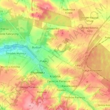
Naam: Topografische kaart Kraśnik, hoogte, reliëf.
Locatie: Kraśnik, Kraśnik County, Lublin Voivodeship, Poland (50.91061 22.13681 50.97629 22.29015)
Gemiddelde hoogte: 232 m
Minimale hoogte: 179 m
Maximale hoogte: 278 m
Andere topografische kaarten
Klik op een kaart om zijn topografie, zijn hoogte en zijn reliëf te bekijken.
Kraśnik
Poland > Lublin Voivodeship > Kraśnik County > Popkowice
Kraśnik, Popkowice, gmina Urzędów, Kraśnik County, Lublin Voivodeship, Poland
Gemiddelde hoogte: 229 m