
Topografische kaart Michigan City
Interactieve kaart
Klik op de kaart om de hoogte weer te geven.
Over deze kaart
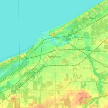
Naam: Topografische kaart Michigan City, hoogte, reliëf.
Locatie: Michigan City, LaPorte County, Indiana, United States (41.66581 -86.93268 41.75345 -86.81609)
Gemiddelde hoogte: 188 m
Minimale hoogte: 172 m
Maximale hoogte: 212 m
Andere topografische kaarten
Klik op een kaart om zijn topografie, zijn hoogte en zijn reliëf te bekijken.
Fish Lake
United States > Indiana > LaPorte County
Fish Lake, LaPorte County, Indiana, 46365, United States
Gemiddelde hoogte: 215 m
Trail Creek
United States > Indiana > LaPorte County
Trail Creek, LaPorte County, Indiana, United States
Gemiddelde hoogte: 194 m
Kingsbury
United States > Indiana > LaPorte County
Kingsbury, LaPorte County, Indiana, 46345, United States
Gemiddelde hoogte: 227 m
Fish Creek
United States > Indiana > LaPorte County
Fish Creek, LaPorte County, Indiana, 46365, United States
Gemiddelde hoogte: 217 m
Long Beach
United States > Indiana > LaPorte County
Long Beach, LaPorte County, Indiana, United States
Gemiddelde hoogte: 184 m
La Porte
United States > Indiana > LaPorte County
La Porte, LaPorte County, Indiana, 46350, United States
Gemiddelde hoogte: 247 m