
Topografische kaart Lake Chelan
Interactieve kaart
Klik op de kaart om de hoogte weer te geven.
Lake Chelan
Lake Chelan (/ʃəˈlæn/ shə-LAN) is a narrow, 50.5 mi (81.3 km) long lake in Chelan County, north-central Washington state, U.S. It is an overdeepened lake and resembles a fjord, with an average width of 1.3 mi (2.1 km). Near its upper end, the lake surface lies more than 6,600 ft (2,000 m) below peaks less than 3 mi (4.8 km) away. Before 1927, Lake Chelan was the largest natural lake in the state in terms of both surface area and water volume. Upon the completion of Lake Chelan Dam in 1927, the elevation of the lake was increased by 21 ft (6.4 m) to its present maximum-capacity elevation of 1,100 ft (340 m).
Over deze kaart
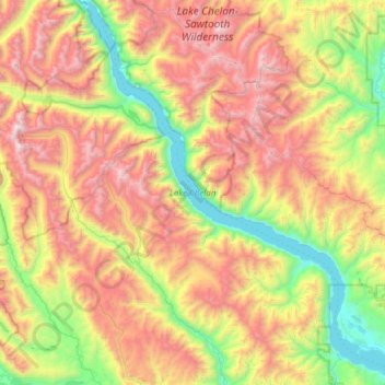
Naam: Topografische kaart Lake Chelan, hoogte, reliëf.
Gemiddelde hoogte: 1.358 m
Minimale hoogte: 323 m
Maximale hoogte: 2.796 m
Andere topografische kaarten
Klik op een kaart om zijn topografie, zijn hoogte en zijn reliëf te bekijken.