
Topografische kaart Sowerby Bridge
Klik op de kaart om de hoogte weer te geven.
Over deze kaart
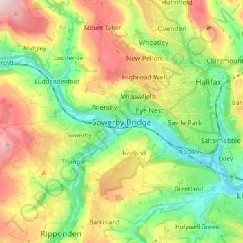
Naam: Topografische kaart Sowerby Bridge, hoogte, reliëf.
Gemiddelde hoogte: 200 m
Minimale hoogte: 65 m
Maximale hoogte: 407 m
Andere topografische kaarten
Klik op een kaart om zijn topografie, zijn hoogte en zijn reliëf te bekijken.
Todmorden
United Kingdom > England > Calderdale > Lydgate
Todmorden Town Hall, which was designed in the Neo-Classical style, dominates the centre of the town. The building straddles the Walsden Water, a tributary of the River Calder, and was situated in both Lancashire and Yorkshire until the administrative county boundary was moved on 1 January 1888. Designed by…
Gemiddelde hoogte: 311 m
Calder & Hebble Navigation Halifax Cut
United Kingdom > England > Calderdale > Skircoat Green
Gemiddelde hoogte: 136 m
Ragby Plantation
United Kingdom > England > Calderdale > Todmorden > Walsden > Bottoms
Gemiddelde hoogte: 293 m
Gaddings Dam
United Kingdom > England > Calderdale > Todmorden > Walsden
Gaddings Dam is a locally owned reservoir near to Todmorden in West Yorkshire, England. The dam was built to power water mills in the Todmorden area, being superseded by steam power and left redundant. It is notable for having a sandy beach at the north-eastern side which attracts people to it during the…
Gemiddelde hoogte: 283 m
Todmorden
United Kingdom > England > Calderdale
Todmorden Town Hall, which was designed in the Neo-Classical style, dominates the centre of the town. The building straddles the Walsden Water, a tributary of the River Calder, and was situated in both Lancashire and Yorkshire until the administrative county boundary was moved on 1 January 1888. Designed by…
Gemiddelde hoogte: 311 m