
Topografische kaart Stanthorpe
Interactieve kaart
Klik op de kaart om de hoogte weer te geven.
Over deze kaart
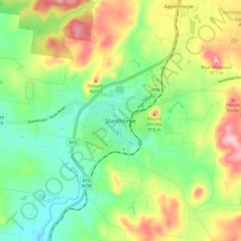
Naam: Topografische kaart Stanthorpe, hoogte, reliëf.
Gemiddelde hoogte: 840 m
Minimale hoogte: 760 m
Maximale hoogte: 966 m
Owing to its elevation, Stanthorpe features a subtropical highland climate. At an altitude of 811 metres (2,661 ft), Stanthorpe holds the record for the lowest temperature recorded in Queensland at −10.6 °C (12.9 °F) on 23 June 1961. Sleet and light snowfalls are occasionally recorded, with the most significant snowfall in over 30 years occurring on 17 July 2015.