
Topografische kaart Guímara
Interactieve kaart
Klik op de kaart om de hoogte weer te geven.
Over deze kaart
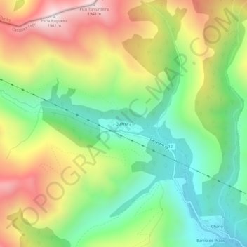
Naam: Topografische kaart Guímara, hoogte, reliëf.
Locatie: Guímara, Peranzanes, El Bierzo, León, Castilla y León, España (42.87930 -6.70969 42.91930 -6.66969)
Gemiddelde hoogte: 1.370 m
Minimale hoogte: 956 m
Maximale hoogte: 1.948 m
Andere topografische kaarten
Klik op een kaart om zijn topografie, zijn hoogte en zijn reliëf te bekijken.
Fresnedelo
España > Castilla y León > El Bierzo > Peranzanes
Fresnedelo, Peranzanes, El Bierzo, León, Castilla y León, 24429, España
Gemiddelde hoogte: 1.070 m
Fornela
España > Castilla y León > El Bierzo > Peranzanes
Fornela, Peranzanes, El Bierzo, León, Castilla y León, 24429, España
Gemiddelde hoogte: 1.178 m
Trascastro
España > Castilla y León > El Bierzo > Peranzanes
Trascastro, Peranzanes, El Bierzo, León, Castilla y León, 24429, España
Gemiddelde hoogte: 1.181 m