
Topografische kaart Sherwood
Interactieve kaart
Klik op de kaart om de hoogte weer te geven.
Over deze kaart
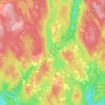
Naam: Topografische kaart Sherwood, hoogte, reliëf.
Gemiddelde hoogte: 182 m
Minimale hoogte: 84 m
Maximale hoogte: 264 m
Andere topografische kaarten
Klik op een kaart om zijn topografie, zijn hoogte en zijn reliëf te bekijken.
Oak Island
Canada > Nouvelle-Écosse > Lunenburg County > Western Shore
Oak Island, Western Shore, Chester District Municipality, Lunenburg County, Nouvelle-Écosse, B0J 3M0, Canada
Gemiddelde hoogte: 2 m
Hubbards
Canada > Nouvelle-Écosse > Lunenburg County > Hubbards
Hubbards, Chester District Municipality, Lunenburg County, Nouvelle-Écosse, B0J 1T0, Canada
Gemiddelde hoogte: 57 m