
Topografische kaart Monsey
Interactieve kaart
Klik op de kaart om de hoogte weer te geven.
Over deze kaart
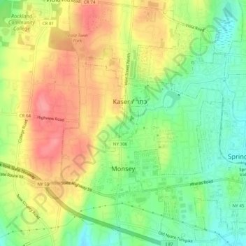
Naam: Topografische kaart Monsey, hoogte, reliëf.
Gemiddelde hoogte: 172 m
Minimale hoogte: 132 m
Maximale hoogte: 214 m
Andere topografische kaarten
Klik op een kaart om zijn topografie, zijn hoogte en zijn reliëf te bekijken.
Fort Clinton
United States > New York > Rockland County > Town of Stony Point
Fort Clinton, Town of Stony Point, Rockland County, New York, 10922, United States
Gemiddelde hoogte: 111 m
Village of Chestnut Ridge
United States > New York > Rockland County
Village of Chestnut Ridge, Town of Ramapo, Rockland County, New York, United States
Gemiddelde hoogte: 127 m
Buckberg
United States > New York > Rockland County > Town of Stony Point
Buckberg, Town of Stony Point, Rockland County, New York, 10986, United States
Gemiddelde hoogte: 108 m
Blauvelt
United States > New York > Rockland County
Blauvelt, Town of Orangetown, Rockland County, New York, 10913, United States
Gemiddelde hoogte: 63 m
Garnerville
United States > New York > Rockland County > Village of West Haverstraw
Garnerville, Village of West Haverstraw, Town of Haverstraw, Rockland County, New York, 10923, United States
Gemiddelde hoogte: 80 m
Antrim
United States > New York > Rockland County > Town of Ramapo > Village of Suffern
Antrim, Village of Suffern, Town of Ramapo, Rockland County, New York, 10901, United States
Gemiddelde hoogte: 140 m
Suffern
United States > New York > Rockland County > Suffern > Suffern
Suffern, Town of Ramapo, Rockland County, New York, 07495, United States
Gemiddelde hoogte: 159 m