
Topografische kaart Gangotri National Park
Interactieve kaart
Klik op de kaart om de hoogte weer te geven.
Over deze kaart
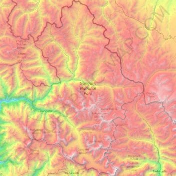
Naam: Topografische kaart Gangotri National Park, hoogte, reliëf.
Gemiddelde hoogte: 5.008 m
Minimale hoogte: 2.497 m
Maximale hoogte: 7.135 m
The park harbors Western Himalayan subalpine conifer forests at lower elevations and Western Himalayan alpine shrub and meadows at higher elevations. Vegetation consist of chirpine deodar, fir, spruce, oak and rhododendrons.
Andere topografische kaarten
Klik op een kaart om zijn topografie, zijn hoogte en zijn reliëf te bekijken.
Didsari
India > Uttarakhand > Bhatwari
Didsari, Bhatwari, Uttarkashi district, Uttarakhand, India
Gemiddelde hoogte: 1.801 m
Dayara
India > Uttarakhand > Bhatwari
Dayara, Bhatwari, Uttarkashi district, Uttarakhand, India
Gemiddelde hoogte: 3.409 m
Uttarkashi
India > Uttarakhand > Bhatwari
Uttarkashi, Bhatwari, Uttarkashi district, Uttarakhand, 249193, India
Gemiddelde hoogte: 1.619 m
Gangotri
India > Uttarakhand > Bhatwari
Gangotri, Bhatwari, Uttarkashi District, Uttarakhand, India
Gemiddelde hoogte: 4.139 m
Shivling
India > Uttarakhand > Bhatwari
Shivling, Bhatwari, Uttarkashi district, Uttarakhand, India
Gemiddelde hoogte: 5.440 m
Barsu
India > Uttarakhand > Bhatwari > Barsu
Barsu, Bhatwari, Uttarkashi, Uttarakhand, India
Gemiddelde hoogte: 2.322 m
Raithal
India > Uttarakhand > Bhatwari > Raithal
Raithal, Bhatwari, Uttarkashi, Uttarakhand, India
Gemiddelde hoogte: 2.122 m
Bhaironghati
India > Uttarakhand > Bhatwari > Lanka > Bhaironghati
Bhaironghati, Lanka, Bhatwari, Uttarkashi, Uttarakhand, India
Gemiddelde hoogte: 3.227 m
Bhatwari
India > Uttarakhand > Bhatwari
Bhatwari, Uttarkashi district, Uttarakhand, India
Gemiddelde hoogte: 4.572 m
Gangotri Glacier
India > Uttarakhand > Bhatwari
Gangotri Glacier, Bhatwari, Uttarkashi, Uttarakhand, India
Gemiddelde hoogte: 5.259 m