
Topografische kaart Cuernavaca
Interactieve kaart
Klik op de kaart om de hoogte weer te geven.
Cuernavaca
The city is located in a tropical region, but its temperature is fairly constant at 21–26 °C (70–79 °F). It is located on the southern slope of the Sierra de Chichinautzin mountains. In the morning, warm air flows up the mountains from the valley below and in the late afternoon, cooler air flows down from the higher elevations. One ubiquitous flowering plant in the city is the bougainvillea.
Over deze kaart
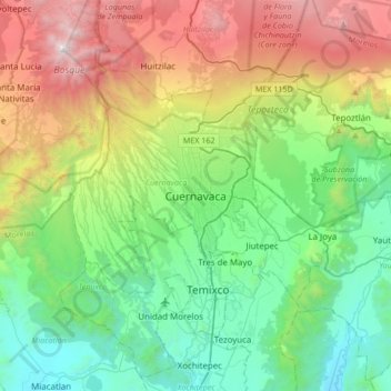
Naam: Topografische kaart Cuernavaca, hoogte, reliëf.
Locatie: Cuernavaca, Morelos, 62000, Mexico (18.76183 -99.39423 19.08183 -99.07423)
Gemiddelde hoogte: 1.822 m
Minimale hoogte: 965 m
Maximale hoogte: 3.679 m