
Doe een donatie
Rust jezelf uit voor je volgende avontuur:
Als Amazon-partner verdient deze site een commissie op in aanmerking komende aankopen, zonder extra kosten voor jou.
Topografische kaart Corpus Christi
Klik op de kaart om de hoogte weer te geven.
Doe een donatie
Rust jezelf uit voor je volgende avontuur:
Als Amazon-partner verdient deze site een commissie op in aanmerking komende aankopen, zonder extra kosten voor jou.
Corpus Christi
Corpus Christi features a diverse coastal topography characterized by its proximity to the Gulf of Mexico. The landscape includes sandy beaches, barrier islands, and extensive estuarine systems such as the Nueces Estuary and Corpus Christi Bay, which are crucial habitats for wildlife. The region is predominantly flat with elevations generally ranging from sea level to approximately 30 feet (9 meters) above sea level, making it prone to coastal influences and susceptible to flooding during storms. Additionally, the area is dotted with salt marshes and wetlands, contributing to its ecological richness while supporting a variety of marine and terrestrial species.
Doe een donatie
Rust jezelf uit voor je volgende avontuur:
Als Amazon-partner verdient deze site een commissie op in aanmerking komende aankopen, zonder extra kosten voor jou.
Over deze kaart
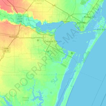
Naam: Topografische kaart Corpus Christi, hoogte, reliëf.
Locatie: Corpus Christi, Nueces County, Texas, United States (27.48357 -97.68274 27.89964 -96.96111)
Gemiddelde hoogte: 8 m
Minimale hoogte: -3 m
Maximale hoogte: 38 m
Doe een donatie
Rust jezelf uit voor je volgende avontuur:
Als Amazon-partner verdient deze site een commissie op in aanmerking komende aankopen, zonder extra kosten voor jou.
Andere topografische kaarten
Klik op een kaart om zijn topografie, zijn hoogte en zijn reliëf te bekijken.