
Topografische kaart Bois de Boulogne
Interactieve kaart
Klik op de kaart om de hoogte weer te geven.
Over deze kaart
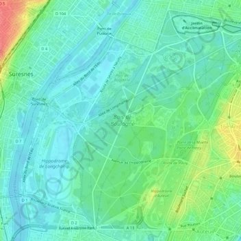
Naam: Topografische kaart Bois de Boulogne, hoogte, reliëf.
Gemiddelde hoogte: 43 m
Minimale hoogte: 26 m
Maximale hoogte: 88 m
Varé bungled the assignment. He failed to take into account the difference in elevation between the beginning of the stream and the end; if his plan had been followed, the upper part of the stream would have been empty, and the lower portion flooded. When Haussmann saw the partially finished stream, he saw the problem immediately and had the elevations measured. He dismissed the unfortunate Varé and Hittorff, and designed the solution himself; an upper lake and a lower lake, divided by an elevated road, which serves as a dam, and a cascade which allows the water to flow between the lakes. This is the design still seen today.