Geolokaliseren

Topografische kaart Comal County

Interactieve kaart

Klik op de kaart om de hoogte weer te geven.

Over deze kaart

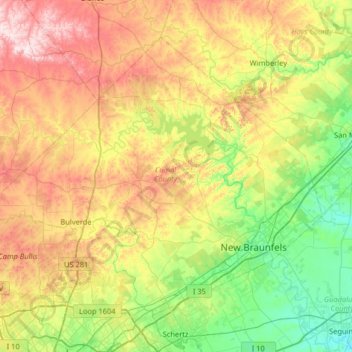
Naam: Topografische kaart Comal County, hoogte, reliëf.

Locatie: Comal County, Texas, VS (29.59434 -98.64622 30.03791 -97.99927)

Gemiddelde hoogte: 311 m

Minimale hoogte: 145 m

Maximale hoogte: 589 m

Andere topografische kaarten

Klik op een kaart om zijn topografie, zijn hoogte en zijn reliëf te bekijken.

Galveston County

VS > Texas

Galveston County, Texas, VS

Gemiddelde hoogte: 0 m

Point Loma

VS > Texas > Point Loma

Point Loma, San Patricio County, Texas, 78368, VS

Gemiddelde hoogte: 34 m

Jesus Maria Colonia

VS > Texas > Jesus Maria Colonia

Jesus Maria Colonia, Hidalgo County, Texas, 78579, VS

Gemiddelde hoogte: 23 m

Boling

VS > Texas > Boling

Boling, Wharton County, Texas, 77420, VS

Gemiddelde hoogte: 24 m

Raymondville

VS > Texas > Raymondville

Raymondville, Willacy County, Texas, VS

Gemiddelde hoogte: 12 m

Bryce

VS > Texas > Bryce

Bryce, Rusk County, Texas, VS

Gemiddelde hoogte: 128 m

North Shore

VS > Texas > North Shore

North Shore, Harris County, Texas, 77339, VS

Gemiddelde hoogte: 21 m

Culberson County

VS > Texas

Culberson County, Texas, VS

Gemiddelde hoogte: 1.253 m

Linden

VS > Texas > Linden

Linden, Cass County, Texas, 75563, VS

Gemiddelde hoogte: 107 m

Weser

VS > Texas > Weser

Weser, Goliad County, Texas, VS

Gemiddelde hoogte: 68 m

Nelson City

VS > Texas > Nelson City

Nelson City, Kendall County, Texas, VS

Gemiddelde hoogte: 485 m