
Topografische kaart Coosane
Interactieve kaart
Klik op de kaart om de hoogte weer te geven.
Over deze kaart
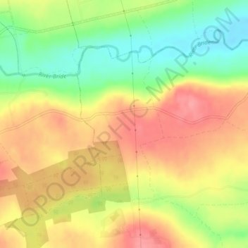
Naam: Topografische kaart Coosane, hoogte, reliëf.
Gemiddelde hoogte: 108 m
Minimale hoogte: 60 m
Maximale hoogte: 147 m
Andere topografische kaarten
Klik op een kaart om zijn topografie, zijn hoogte en zijn reliëf te bekijken.
Lysaghtstown
Ireland > County Cork > Municipal District of Cobh
Lysaghtstown, Carrigtohill ED, Municipal District of Cobh, County Cork, Munster, Ireland
Gemiddelde hoogte: 81 m
Tullagreen
Ireland > County Cork > Municipal District of Cobh
Tullagreen, Carrigtohill ED, Municipal District of Cobh, County Cork, Munster, Ireland
Gemiddelde hoogte: 12 m
Ballynabortagh
Ireland > County Cork > Municipal District of Cobh
Ballynabortagh, Killeagh, Municipal District of Cobh, County Cork, Munster, Ireland
Gemiddelde hoogte: 153 m
Ballynanelagh
Ireland > County Cork > Municipal District of Cobh > Knockraha
Ballynanelagh, Knockraha, Municipal District of Cobh, County Cork, Munster, Ireland
Gemiddelde hoogte: 113 m