
Topografische kaart The Municipal District of Athy
Interactieve kaart
Klik op de kaart om de hoogte weer te geven.
Over deze kaart
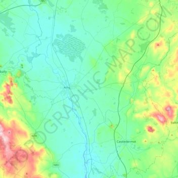
Naam: Topografische kaart The Municipal District of Athy, hoogte, reliëf.
Gemiddelde hoogte: 101 m
Minimale hoogte: 47 m
Maximale hoogte: 312 m
Andere topografische kaarten
Klik op een kaart om zijn topografie, zijn hoogte en zijn reliëf te bekijken.
Grand Canal - Barrow Line
Ireland > County Kildare > Athy
Grand Canal - Barrow Line, Athy, Athy Urban West ED, The Municipal District of Athy, County Kildare, Leinster, R14 EH50, Ireland
Gemiddelde hoogte: 60 m
Allenwood
Allenwood, The Municipal District of Clane — Maynooth, County Kildare, Leinster, W91 XW6H, Ireland
Gemiddelde hoogte: 82 m
Newbridge
Newbridge, The Municipal District of Kildare — Newbridge, County Kildare, Leinster, Ireland
Gemiddelde hoogte: 95 m
Sallins
Sallins, The Municipal District of Naas, County Kildare, Leinster, Ireland
Gemiddelde hoogte: 81 m
Ballysax
Ballysax, The Municipal District of Kildare — Newbridge, County Kildare, Leinster, Ireland
Gemiddelde hoogte: 107 m
Kilkea Upper
Kilkea Upper, Kilkea ED, The Municipal District of Athy, County Kildare, Leinster, Ireland
Gemiddelde hoogte: 82 m
Carbury
Carbury, The Municipal District of Clane — Maynooth, County Kildare, Leinster, W91 K763, Ireland
Gemiddelde hoogte: 90 m
Castledermot
Castledermot, Abbeylands, Castledermot ED, The Municipal District of Athy, County Kildare, Leinster, Ireland
Gemiddelde hoogte: 83 m
Clane
Clane, Alexandra Walk, Clane ED, The Municipal District of Clane — Maynooth, County Kildare, Leinster, Ireland
Gemiddelde hoogte: 70 m
Straffan
Ireland > County Kildare > Straffan
Straffan, The Municipal District of Clane — Maynooth, County Kildare, Leinster, W23 V628, Ireland
Gemiddelde hoogte: 65 m
Athy
Athy, Athy Urban East ED, The Municipal District of Athy, County Kildare, Leinster, R14 XD30, Ireland
Gemiddelde hoogte: 61 m
The Municipal District of Clane — Maynooth
The Municipal District of Clane — Maynooth, County Kildare, Leinster, Ireland
Gemiddelde hoogte: 86 m
Rathangan
Ireland > County Kildare > Rathangan
Rathangan, County Kildare, Leinster, Ireland
Gemiddelde hoogte: 76 m
Ballyteague Bog
Ballyteague Bog, Rathernan ED, The Municipal District of Kildare — Newbridge, County Kildare, Leinster, Ireland
Gemiddelde hoogte: 77 m
Leixlip
Leixlip, The Municipal District of Celbridge — Leixlip, County Kildare, Leinster, Ireland
Gemiddelde hoogte: 53 m
Clane
Ireland > County Kildare > Clane
Clane, The Municipal District of Clane — Maynooth, County Kildare, Leinster, W91 X253, Ireland
Gemiddelde hoogte: 78 m
The Municipal District of Kildare — Newbridge
The Municipal District of Kildare — Newbridge, County Kildare, Leinster, Ireland
Gemiddelde hoogte: 93 m
The Municipal District of Naas
The Municipal District of Naas, County Kildare, Leinster, Ireland
Gemiddelde hoogte: 152 m
Castledermot
Ireland > County Kildare > Castledermot
Castledermot, The Municipal District of Athy, County Kildare, Leinster, Ireland
Gemiddelde hoogte: 94 m