
Topografische kaart Mission
Interactieve kaart
Klik op de kaart om de hoogte weer te geven.
Over deze kaart
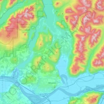
Naam: Topografische kaart Mission, hoogte, reliëf.
Gemiddelde hoogte: 345 m
Minimale hoogte: -1 m
Maximale hoogte: 1.329 m
The western part of the district, the Stave Valley, is largely rural and forested but its watercourse is home to what was the largest hydroelectric project in British Columbia until the Bridge River Power Project opened in 1961. It was built by the British Columbia Electric Railway (BCER) to provide power to the electric street railway and interurban system in Vancouver. The Stave Falls Power Co. operated a light-gauge railway for passenger and freight service up the lower canyon of the river to the dam at Stave Falls. During the construction of the Ruskin Dam (completed 1931) the railway was rebuilt at a higher elevation so as to skirt the new Hayward Lake reservoir. The rail line has long been discontinued, but the old grade and its trestles are now part of a recreation trail circling the reservoir.
Andere topografische kaarten
Klik op een kaart om zijn topografie, zijn hoogte en zijn reliëf te bekijken.
Kwawkwawapilt
Canada > British Columbia > Fraser Valley Regional District
Kwawkwawapilt, Fraser Valley Regional District, British Columbia, V2P 6Z3, Canada
Gemiddelde hoogte: 13 m
Durieu
Canada > British Columbia > Fraser Valley Regional District > Area F (McConnell Creek/Hatzic Prairie)
Durieu, Area F (McConnell Creek/Hatzic Prairie), Fraser Valley Regional District, British Columbia, V2V 4J1, Canada
Gemiddelde hoogte: 142 m
Hope
Canada > British Columbia > Fraser Valley Regional District
Hope, Fraser Valley Regional District, British Columbia, Canada
Gemiddelde hoogte: 674 m
Area C (Sasquatch Country)
Canada > British Columbia > Fraser Valley Regional District
Area C (Sasquatch Country), Fraser Valley Regional District, British Columbia, Canada
Gemiddelde hoogte: 988 m
Skook Jim Mountain
Canada > British Columbia > Fraser Valley Regional District > Area C (Sasquatch Country)
Skook Jim Mountain, Area C (Sasquatch Country), Fraser Valley Regional District, British Columbia, Canada
Gemiddelde hoogte: 2.216 m
Stone Garden
Canada > British Columbia > Fraser Valley Regional District > Area B (South Fraser Canyon/Sunshine Valley)
Stone Garden, Area B (South Fraser Canyon/Sunshine Valley), Fraser Valley Regional District, British Columbia, V0X 1L2, Canada
Gemiddelde hoogte: 319 m
Abbotsford
Canada > British Columbia > Fraser Valley Regional District > Abbotsford
Abbotsford, Fraser Valley Regional District, British Columbia, V2T 1W7, Canada
Gemiddelde hoogte: 115 m
Abbotsford
Canada > British Columbia > Fraser Valley Regional District
Abbotsford, Fraser Valley Regional District, British Columbia, Canada
Gemiddelde hoogte: 99 m
Chilliwack
Canada > British Columbia > Fraser Valley Regional District
Chilliwack, Fraser Valley Regional District, British Columbia, Canada
Gemiddelde hoogte: 240 m
Agassiz
Canada > British Columbia > Fraser Valley Regional District > Kent
Agassiz, Kent, Fraser Valley Regional District, British Columbia, V0M 1A2, Canada
Gemiddelde hoogte: 48 m