
Topografische kaart Pleasantville
Interactieve kaart
Klik op de kaart om de hoogte weer te geven.
Over deze kaart
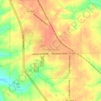
Naam: Topografische kaart Pleasantville, hoogte, reliëf.
Locatie: Pleasantville, Marion County, Iowa, 50225, United States (41.37112 -93.28603 41.40175 -93.25716)
Gemiddelde hoogte: 274 m
Minimale hoogte: 243 m
Maximale hoogte: 287 m
Andere topografische kaarten
Klik op een kaart om zijn topografie, zijn hoogte en zijn reliëf te bekijken.
Pella
United States > Iowa > Marion County
Pella, Marion County, Iowa, United States
Gemiddelde hoogte: 254 m
Pella
United States > Iowa > Marion County > Pella
Pella, Marion County, Iowa, 50219, United States
Gemiddelde hoogte: 253 m
Pleasantville
United States > Iowa > Marion County > Pleasantville
Pleasantville, Marion County, Iowa, 50225, United States
Gemiddelde hoogte: 271 m
Knoxville
United States > Iowa > Marion County
Knoxville, Marion County, Iowa, United States
Gemiddelde hoogte: 265 m