
Topografische kaart Mitzpe Ramon
Interactieve kaart
Klik op de kaart om de hoogte weer te geven.
Over deze kaart
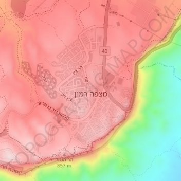
Naam: Topografische kaart Mitzpe Ramon, hoogte, reliëf.
Gemiddelde hoogte: 782 m
Minimale hoogte: 557 m
Maximale hoogte: 887 m
Mitzpe Ramon (Hebrew: מִצְפֵּה רָמוֹן, Ramon Lookout; Arabic: متسبي رمون) is a local council in the Negev desert of southern Israel. It is situated on the northern ridge at an elevation of 860 meters (2,800 feet) overlooking the world's largest erosion cirque, known as the Makhtesh Ramon. In 2021 it had a population of 5,178.
Andere topografische kaarten
Klik op een kaart om zijn topografie, zijn hoogte en zijn reliëf te bekijken.
Eilat
Eilat, Beersheba Subdistrict, South District, 8804625, Israel
Gemiddelde hoogte: 405 m
Yeruham
Yeruham, Beersheba Subdistrict, South District, Israel
Gemiddelde hoogte: 508 m
Negev
Israel > South District > Ramat Negev Regional Council
Negev, Ramat Negev Regional Council, Beersheba Subdistrict, South District, Israel
Gemiddelde hoogte: 529 m
Kiryat Gat
Kiryat Gat, Ashkelon Subdistrict, South District, 8202280, Israel
Gemiddelde hoogte: 133 m
Beer Sheva
Israel > South District > Beer Sheva
Beer Sheva, Beersheba Subdistrict, South District, Israel
Gemiddelde hoogte: 284 m