
Topografische kaart Philippi
Interactieve kaart
Klik op de kaart om de hoogte weer te geven.
Over deze kaart
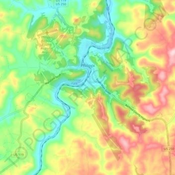
Naam: Topografische kaart Philippi, hoogte, reliëf.
Gemiddelde hoogte: 490 m
Minimale hoogte: 388 m
Maximale hoogte: 626 m
Throughout its history, Philippi has suffered from floods because of its proximity to the river and the relatively low elevation of most of the town. The most damaging of these came in November 1985. The town has since adopted a flood plain management plan.
Andere topografische kaarten
Klik op een kaart om zijn topografie, zijn hoogte en zijn reliëf te bekijken.
Volga
United States > West Virginia > Barbour County
Volga, Barbour County, West Virginia, 26238, United States
Gemiddelde hoogte: 460 m
Moatsville
United States > West Virginia > Barbour County
Moatsville, Barbour County, West Virginia, 26405, United States
Gemiddelde hoogte: 476 m
Galloway
United States > West Virginia > Barbour County
Galloway, Barbour County, West Virginia, 26349, United States
Gemiddelde hoogte: 403 m
Century Junction
United States > West Virginia > Barbour County
Century Junction, Barbour County, West Virginia, 26238, United States
Gemiddelde hoogte: 456 m
Union
United States > West Virginia > Barbour County
Union, Barbour County, West Virginia, United States
Gemiddelde hoogte: 545 m
Belington
United States > West Virginia > Barbour County
Belington, Barbour County, West Virginia, 26250, United States
Gemiddelde hoogte: 542 m
Independence
United States > West Virginia > Barbour County > Independence
Independence, Barbour County, West Virginia, 26416, United States
Gemiddelde hoogte: 501 m
Junior
United States > West Virginia > Barbour County
Junior, Barbour County, West Virginia, 26275, United States
Gemiddelde hoogte: 587 m