
Topografische kaart Cottonwood Point
Interactieve kaart
Klik op de kaart om de hoogte weer te geven.
Over deze kaart
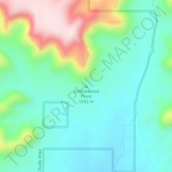
Naam: Topografische kaart Cottonwood Point, hoogte, reliëf.
Locatie: Cottonwood Point, Kane County, Utah, United States (37.02494 -112.62026 37.02504 -112.62016)
Gemiddelde hoogte: 1.641 m
Minimale hoogte: 1.527 m
Maximale hoogte: 1.931 m
Andere topografische kaarten
Klik op een kaart om zijn topografie, zijn hoogte en zijn reliëf te bekijken.
Long Valley Junction
United States > Utah > Kane County
Long Valley Junction, Kane County, Utah, 84710, United States
Gemiddelde hoogte: 2.295 m
Navajo Lake
United States > Utah > Kane County > Navajo Lake Lodge
Navajo Lake, Navajo Lake Lodge, Kane County, Utah, United States
Gemiddelde hoogte: 2.851 m
Coyote Gulch
United States > Utah > Kane County
Coyote Gulch, Kane County, Utah, United States
Gemiddelde hoogte: 1.361 m
Lone Rock Beach
United States > Utah > Kane County
Lone Rock Beach, Kane County, Utah, United States
Gemiddelde hoogte: 1.134 m
Spooky Gulch
United States > Utah > Kane County
Spooky Gulch, Kane County, Utah, United States
Gemiddelde hoogte: 1.472 m