
Topografische kaart Castle Rock
Interactieve kaart
Klik op de kaart om de hoogte weer te geven.
Over deze kaart
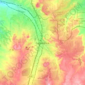
Naam: Topografische kaart Castle Rock, hoogte, reliëf.
Locatie: Castle Rock, Douglas County, Colorado, United States (39.31127 -104.91980 39.43495 -104.76128)
Gemiddelde hoogte: 1.952 m
Minimale hoogte: 1.783 m
Maximale hoogte: 2.116 m
Castle Rock is located at 39°22′20″N 104°51′22″W / 39.37222°N 104.85611°W / 39.37222; -104.85611 (39.372212, −104.856090) at an elevation of 6,224 feet (1,897 m). Castle Rock is in central Colorado at the junction of Interstate 25 and State Highway 86, 28 mi (45 km) south of downtown Denver and 37 mi (60 km) north of Colorado Springs.
Andere topografische kaarten
Klik op een kaart om zijn topografie, zijn hoogte en zijn reliëf te bekijken.
Highlands Ranch
United States > Colorado > Douglas County
Highlands Ranch, Douglas County, Colorado, 80126, United States
Gemiddelde hoogte: 1.758 m
Aurora Rampart Reservoir
United States > Colorado > Douglas County
Aurora Rampart Reservoir, Douglas County, Colorado, United States
Gemiddelde hoogte: 1.818 m