
Topografische kaart Strathcona Science Provincial Park
Interactieve kaart
Klik op de kaart om de hoogte weer te geven.
Strathcona Science Provincial Park
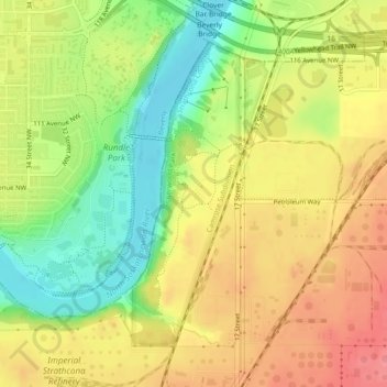
The park is situated in the North Saskatchewan River valley, on both banks of the river, at an elevation of 625 m (2,051 ft) and has a surface of 2.9 km2 (1.1 sq mi). It was established on December 12, 1979 and is maintained by Alberta Tourism, Parks and Recreation.
Over deze kaart
Naam: Topografische kaart Strathcona Science Provincial Park, hoogte, reliëf.
Gemiddelde hoogte: 653 m
Minimale hoogte: 608 m
Maximale hoogte: 691 m