
Topografische kaart Zalewo
Interactieve kaart
Klik op de kaart om de hoogte weer te geven.
Over deze kaart
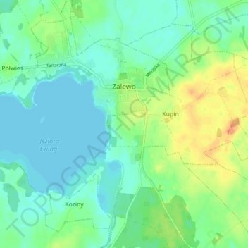
Naam: Topografische kaart Zalewo, hoogte, reliëf.
Gemiddelde hoogte: 107 m
Minimale hoogte: 95 m
Maximale hoogte: 132 m
Andere topografische kaarten
Klik op een kaart om zijn topografie, zijn hoogte en zijn reliëf te bekijken.
Iława
Poland > Warmian-Masurian Voivodeship > Iława County > Iława
Iława, Iława County, Warmian-Masurian Voivodeship, 14-200, Poland
Gemiddelde hoogte: 107 m