
Topografische kaart Ohiwa
Interactieve kaart
Klik op de kaart om de hoogte weer te geven.
Over deze kaart
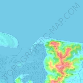
Naam: Topografische kaart Ohiwa, hoogte, reliëf.
Locatie: Ohiwa, Ōpōtiki District, Bay of Plenty, 3198, New Zealand (-38.00876 177.13937 -37.96876 177.17937)
Gemiddelde hoogte: 11 m
Minimale hoogte: 0 m
Maximale hoogte: 115 m
Andere topografische kaarten
Klik op een kaart om zijn topografie, zijn hoogte en zijn reliëf te bekijken.
Parinui
New Zealand > Bay of Plenty > Ōpōtiki District
Parinui, Ōpōtiki District, Bay of Plenty, 3162, New Zealand
Gemiddelde hoogte: 67 m
Whitianga
New Zealand > Bay of Plenty > Ōpōtiki District
Whitianga, Ōpōtiki District, Bay of Plenty, 3162, New Zealand
Gemiddelde hoogte: 42 m
Opotiki
New Zealand > Bay of Plenty > Ōpōtiki District
Opotiki, Ōpōtiki District, Bay of Plenty, 3122, New Zealand
Gemiddelde hoogte: 14 m
Papamoa
New Zealand > Bay of Plenty > Ōpōtiki District
Papamoa, Ōpōtiki District, Bay of Plenty, New Zealand
Gemiddelde hoogte: 544 m
Kaharoa
New Zealand > Bay of Plenty > Ōpōtiki District
Kaharoa, Ōpōtiki District, Bay of Plenty, New Zealand
Gemiddelde hoogte: 721 m