
Topografische kaart North Paravur
Interactieve kaart
Klik op de kaart om de hoogte weer te geven.
Over deze kaart
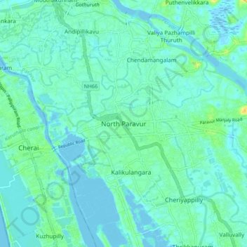
Naam: Topografische kaart North Paravur, hoogte, reliëf.
Gemiddelde hoogte: 5 m
Minimale hoogte: -3 m
Maximale hoogte: 23 m
Paravur is located at 10.14° N 76.7° E[1]. It has an average elevation of 10 metres (32 feet). The town is situated at north end of Ernakulam district and bordering with Thrissur district. The towns in Thrissur district like Kodungallore, Mala, Chalakudy and the towns Kalamassery, Aluva, Angamaly, Vypin island are located near to this town. The Paravur Taluk lies in the flat delta region of the Periyar river and cut by several canals, which have resulted in the formation of many islands. The Kodungalloor Kayal (backwaters) and Varappuzha Kayal (backwaters) are in this taluk. The town and neighboring areas were deeply affected by floods in 2018 due to heavy rain.
Andere topografische kaarten
Klik op een kaart om zijn topografie, zijn hoogte en zijn reliëf te bekijken.
Periyar River
India > Kerala > Paravur > Edayar
Periyar River, Njaarakkaattu, Edayar, Paravur, Ernakulam District, Kerala, India
Gemiddelde hoogte: 8 m
Karumalloor
India > Kerala > Paravur > Manjaly
Karumalloor, Manjaly, Paravur, Ernakulam District, Kerala, India
Gemiddelde hoogte: 7 m
Binanipuram
Binanipuram, Paravur, Ernakulam district, Kerala, 683502, India
Gemiddelde hoogte: 7 m
Thuruthoor
Thuruthoor, Paravur, Ernakulam district, Kerala, 680733, India
Gemiddelde hoogte: 5 m
Cheriyappilly
India > Kerala > Paravur > Cheriyappilly
Cheriyappilly, Paravur, Ernakulam district, Kerala, 683513, India
Gemiddelde hoogte: 5 m