
Doe een donatie
Rust jezelf uit voor je volgende avontuur:
Als Amazon-partner verdient deze site een commissie op in aanmerking komende aankopen, zonder extra kosten voor jou.
Topografische kaart Crawinkel
Klik op de kaart om de hoogte weer te geven.
Doe een donatie
Rust jezelf uit voor je volgende avontuur:
Als Amazon-partner verdient deze site een commissie op in aanmerking komende aankopen, zonder extra kosten voor jou.
Crawinkel
Zu Crawinkel bemerkt Galletti in seiner topographisch-historischen Beschreibung des Gothaer Herzogtums von 1780.
Doe een donatie
Rust jezelf uit voor je volgende avontuur:
Als Amazon-partner verdient deze site een commissie op in aanmerking komende aankopen, zonder extra kosten voor jou.
Over deze kaart
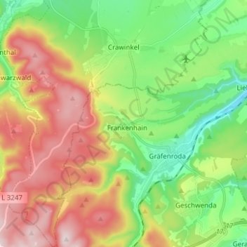
Naam: Topografische kaart Crawinkel, hoogte, reliëf.
Locatie: Crawinkel, Ohrdruf, Landkreis Gotha, Thüringen, Deutschland (50.71792 10.72425 50.79626 10.82820)
Gemiddelde hoogte: 536 m
Minimale hoogte: 366 m
Maximale hoogte: 770 m
Doe een donatie
Rust jezelf uit voor je volgende avontuur:
Als Amazon-partner verdient deze site een commissie op in aanmerking komende aankopen, zonder extra kosten voor jou.