
Topografische kaart Penrith
Interactieve kaart
Klik op de kaart om de hoogte weer te geven.
Over deze kaart
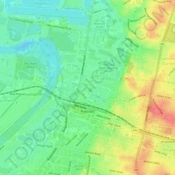
Naam: Topografische kaart Penrith, hoogte, reliëf.
Gemiddelde hoogte: 34 m
Minimale hoogte: 8 m
Maximale hoogte: 73 m
Penrith is a city in New South Wales, Australia, located in Greater Western Sydney, 55 kilometres (31 mi) west of the Sydney central business district on the banks of the Nepean River, on the outskirts of the Cumberland Plain. Its elevation is 32 metres (105 ft).
Andere topografische kaarten
Klik op een kaart om zijn topografie, zijn hoogte en zijn reliëf te bekijken.
Sydney International Regatta Centre
Australia > New South Wales > Sydney > Penrith
Sydney International Regatta Centre, Castlereagh, Penrith, Sydney, Penrith City Council, New South Wales, 2749, Australia
Gemiddelde hoogte: 19 m
Kingswood
Australia > New South Wales > Sydney > Penrith
Kingswood, Penrith, Sydney, Penrith City Council, New South Wales, 2747, Australia
Gemiddelde hoogte: 53 m
Emu Plains
Australia > New South Wales > Sydney > Penrith
Emu Plains, Penrith, Sydney, Penrith City Council, New South Wales, 2750, Australia
Gemiddelde hoogte: 27 m
Cambridge Gardens
Australia > New South Wales > Sydney > Penrith
Cambridge Gardens, Penrith, Sydney, Penrith City Council, New South Wales, 2747, Australia
Gemiddelde hoogte: 46 m