
Topografische kaart Livingston County
Interactieve kaart
Klik op de kaart om de hoogte weer te geven.
Over deze kaart
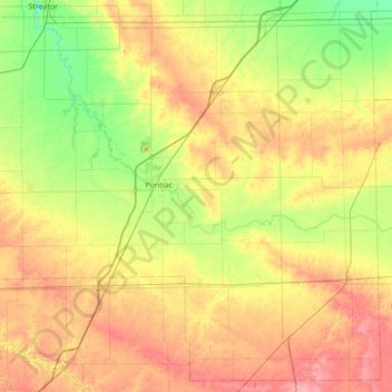
Naam: Topografische kaart Livingston County, hoogte, reliëf.
Locatie: Livingston County, Illinois, USA (40.61567 -88.92986 41.11499 -88.23412)
Gemiddelde hoogte: 212 m
Minimale hoogte: 176 m
Maximale hoogte: 259 m
Andere topografische kaarten
Klik op een kaart om zijn topografie, zijn hoogte en zijn reliëf te bekijken.
West Union
USA > Illinois > West Union
West Union, Clark County, Illinois, 62477, USA
Gemiddelde hoogte: 148 m
Island Grove
USA > Illinois > Island Grove
Island Grove, Jasper County, Illinois, USA
Gemiddelde hoogte: 181 m
Garfield Ridge
Garfield Ridge, Chicago, Cook County, Illinois, USA
Gemiddelde hoogte: 184 m
Montague Island
Montague Island, Rockford, Winnebago County, Illinois, 61104, USA
Gemiddelde hoogte: 254 m
Gilligans Island
Gilligans Island, Nauvoo, Hancock County, Illinois, USA
Gemiddelde hoogte: 183 m