
Topografische kaart Spring Branch
Interactieve kaart
Klik op de kaart om de hoogte weer te geven.
Over deze kaart
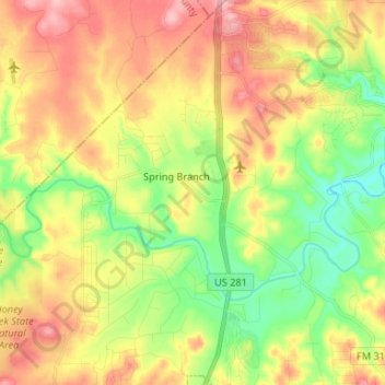
Naam: Topografische kaart Spring Branch, hoogte, reliëf.
Locatie: Spring Branch, Comal County, Texas, United States (29.82779 -98.44823 29.94236 -98.38294)
Gemiddelde hoogte: 347 m
Minimale hoogte: 285 m
Maximale hoogte: 415 m
Andere topografische kaarten
Klik op een kaart om zijn topografie, zijn hoogte en zijn reliëf te bekijken.
Comal River
United States > Texas > Comal County > New Braunfels > Landa Park Estates
Comal River, Landa Park Estates, New Braunfels, Comal County, Texas, 78130, United States
Gemiddelde hoogte: 206 m
Canyon Springs
United States > Texas > Comal County
Canyon Springs, Comal County, Texas, 79133, United States
Gemiddelde hoogte: 310 m
New Braunfels
United States > Texas > Comal County
New Braunfels, Comal County, Texas, United States
Gemiddelde hoogte: 228 m
Bulverde
United States > Texas > Comal County
Bulverde, Comal County, Texas, United States
Gemiddelde hoogte: 364 m
Canyon Lake
United States > Texas > Comal County
Canyon Lake, Comal County, Texas, 78133, United States
Gemiddelde hoogte: 296 m