
Topografische kaart Krasnoyarsk
Interactieve kaart
Klik op de kaart om de hoogte weer te geven.
Over deze kaart
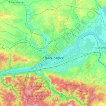
Naam: Topografische kaart Krasnoyarsk, hoogte, reliëf.
Gemiddelde hoogte: 285 m
Minimale hoogte: 118 m
Maximale hoogte: 792 m
The river Yenisei flows from west to east through the city. Due to the Krasnoyarsk hydroelectric dam 32 km (20 mi) upstream, the Yenisei never freezes in winter and never exceeds +14 °C (57 °F) in summer through the city. Near the city center, its elevation is 136 m (446 ft) above sea level. There are several islands in the river, the largest of which are Tatyshev and Otdyha Isles, used mainly for recreation.