
Topografische kaart A Baña
Interactieve kaart
Klik op de kaart om de hoogte weer te geven.
A Baña
Vesía is a town situated near the centre of the A Baña municipality, in the A Coruña province. It is part of the parish of San Vicente, the capital of the municipality. Vesía is at an altitude of 317.6 meters above sea level, and stands at an incline of 20.89%. Vesía has a population of around 40 people, the majority of whom are between 65 and 80 years old as the area has suffered youth emigration.
Over deze kaart
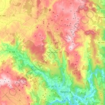
Naam: Topografische kaart A Baña, hoogte, reliëf.
Locatie: A Baña, A Barcala, A Coruña, Galicia, 15863, Spain (42.91627 -8.84152 43.00686 -8.65624)
Gemiddelde hoogte: 325 m
Minimale hoogte: 128 m
Maximale hoogte: 516 m
Andere topografische kaarten
Klik op een kaart om zijn topografie, zijn hoogte en zijn reliëf te bekijken.