
Topografische kaart Milpa Alta
Interactieve kaart
Klik op de kaart om de hoogte weer te geven.
Milpa Alta
It has an average altitude of 2,420 meters above sea level with altitudes varying between 2,300 and 3,600. It is part of the Trans-Mexican Volcanic Belt and the Sierra Chichinautzin volcanic mountain chain, which separates Mexico City from the state of Morelos. The borough is divided into three zones: Ajusco-Teuhtli, the lowest elevations, Topilejo-Milpa Alta in the medium range and Cerro-Tlicuaya at the highest elevations. The main elevations are volcanic and include Cuautzin (3,510), Tulmiac, Ocusacayo (3,220), La Comalera (3,230), San Bartolo (3,200), Tláloc (3,510), Chichinautzin (3,470), Yecahuazac, Quimixtepec, El Oclayuca (3,140), El Pajonal (3,100), El Ocotécatl (3,480), Acopiaxco (3,320), Tetzacoatl (3,310), Tehutli (2,800) Cilcuayo (3,580), Nepanapa (3,460), Texalo (3,560), Oclayuca (3,390), San Miguel (2,988) .
Over deze kaart
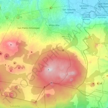
Naam: Topografische kaart Milpa Alta, hoogte, reliëf.
Locatie: Milpa Alta, Mexico City, Mexico (19.04872 -99.16329 19.22770 -98.95239)
Gemiddelde hoogte: 2.842 m
Minimale hoogte: 2.230 m
Maximale hoogte: 3.673 m
Andere topografische kaarten
Klik op een kaart om zijn topografie, zijn hoogte en zijn reliëf te bekijken.