
Topografische kaart Denton
Interactieve kaart
Klik op de kaart om de hoogte weer te geven.
Over deze kaart
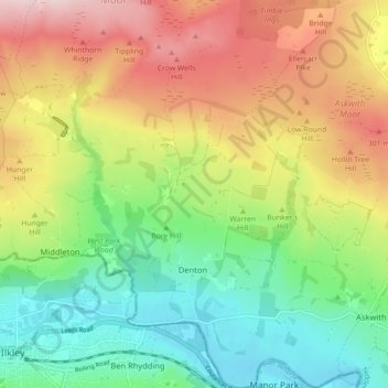
Naam: Topografische kaart Denton, hoogte, reliëf.
Gemiddelde hoogte: 189 m
Minimale hoogte: 62 m
Maximale hoogte: 364 m
Andere topografische kaarten
Klik op een kaart om zijn topografie, zijn hoogte en zijn reliëf te bekijken.
Galphay
United Kingdom > England > North Yorkshire > Harrogate > Galphay
Galphay, Azerley, Harrogate, North Yorkshire, Yorkshire and the Humber, England, HG4 3NJ, United Kingdom
Gemiddelde hoogte: 120 m
Beckwithshaw
United Kingdom > England > North Yorkshire > Harrogate > Beckwithshaw
Beckwithshaw, Harrogate, North Yorkshire, Yorkshire and the Humber, England, HG3 1QW, United Kingdom
Gemiddelde hoogte: 161 m
Fewston
United Kingdom > England > North Yorkshire > Harrogate > Fewston
Fewston, Harrogate, North Yorkshire, Yorkshire and the Humber, England, United Kingdom
Gemiddelde hoogte: 205 m
Bilton-in-Ainsty with Bickerton
United Kingdom > England > North Yorkshire > Harrogate > Bickerton
Bilton-in-Ainsty with Bickerton, Bickerton, Harrogate, North Yorkshire, Yorkshire and the Humber, England, United Kingdom
Gemiddelde hoogte: 28 m