
Topografische kaart Las Vegas
Interactieve kaart
Klik op de kaart om de hoogte weer te geven.
Over deze kaart
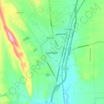
Naam: Topografische kaart Las Vegas, hoogte, reliëf.
Gemiddelde hoogte: 1.994 m
Minimale hoogte: 1.924 m
Maximale hoogte: 2.175 m
Andere topografische kaarten
Klik op een kaart om zijn topografie, zijn hoogte en zijn reliëf te bekijken.
Conchas Dam
United States > New Mexico > San Miguel County > Conchas
Conchas Dam, Conchas, San Miguel County, New Mexico, United States
Gemiddelde hoogte: 1.279 m
Pecos National Historic Park
United States > New Mexico > San Miguel County > Pecos
Pecos National Historic Park, Pecos, San Miguel County, New Mexico, 87535, United States
Gemiddelde hoogte: 2.239 m
Pecos
United States > New Mexico > San Miguel County > Pecos
Pecos, San Miguel County, New Mexico, 87552, United States
Gemiddelde hoogte: 2.146 m
Pendaries Village
United States > New Mexico > San Miguel County > Pendaries Village
Pendaries Village, San Miguel County, New Mexico, 87742, United States
Gemiddelde hoogte: 2.360 m
Rowe
United States > New Mexico > San Miguel County > Rowe
Rowe, San Miguel County, New Mexico, 87562, United States
Gemiddelde hoogte: 2.139 m
Starvation Peak
United States > New Mexico > San Miguel County
Starvation Peak, San Miguel County, New Mexico, 87569, United States
Gemiddelde hoogte: 1.946 m
Pecos
United States > New Mexico > San Miguel County
Pecos, San Miguel County, New Mexico, 87552, United States
Gemiddelde hoogte: 2.131 m