
Topografische kaart Chillicothe
Interactieve kaart
Klik op de kaart om de hoogte weer te geven.
Over deze kaart
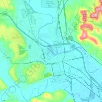
Naam: Topografische kaart Chillicothe, hoogte, reliëf.
Locatie: Chillicothe, Ross County, Ohio, Estados Unidos de América (39.31293 -83.05398 39.37385 -82.94527)
Gemiddelde hoogte: 217 m
Minimale hoogte: 177 m
Maximale hoogte: 385 m