
Topografische kaart Kennedyville
Interactieve kaart
Klik op de kaart om de hoogte weer te geven.
Over deze kaart
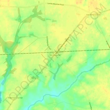
Naam: Topografische kaart Kennedyville, hoogte, reliëf.
Locatie: Kennedyville, Kent County, Maryland, 21645, United States (39.28539 -76.01494 39.32539 -75.97494)
Gemiddelde hoogte: 18 m
Minimale hoogte: 1 m
Maximale hoogte: 27 m
Andere topografische kaarten
Klik op een kaart om zijn topografie, zijn hoogte en zijn reliëf te bekijken.
Millington
United States > Maryland > Kent County
Millington, Kent County, Maryland, United States
Gemiddelde hoogte: 12 m
Chestertown
United States > Maryland > Kent County
Chestertown, Kent County, Maryland, 21620, United States
Gemiddelde hoogte: 11 m
Rock Hall
United States > Maryland > Kent County
Rock Hall, Kent County, Maryland, 21661, United States
Gemiddelde hoogte: 3 m