
Topografische kaart Ulah
Interactieve kaart
Klik op de kaart om de hoogte weer te geven.
Over deze kaart
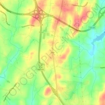
Naam: Topografische kaart Ulah, hoogte, reliëf.
Locatie: Ulah, Randolph County, North Carolina, 27205, United States (35.61541 -79.84670 35.65541 -79.80670)
Gemiddelde hoogte: 237 m
Minimale hoogte: 201 m
Maximale hoogte: 271 m
Andere topografische kaarten
Klik op een kaart om zijn topografie, zijn hoogte en zijn reliëf te bekijken.
Franklinville
United States > North Carolina > Randolph County
Franklinville, Randolph County, North Carolina, United States
Gemiddelde hoogte: 163 m
Asheboro
United States > North Carolina > Randolph County
Asheboro, Randolph County, North Carolina, United States
Gemiddelde hoogte: 208 m
Redding Hills
United States > North Carolina > Randolph County > Asheboro > Redding Hills
Redding Hills, Asheboro, Randolph County, North Carolina, 27203, United States
Gemiddelde hoogte: 223 m