Geolokaliseren

Topografische kaart Brookland

Interactieve kaart

Klik op de kaart om de hoogte weer te geven.

Over deze kaart

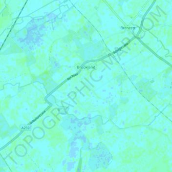
Naam: Topografische kaart Brookland, hoogte, reliëf.

Locatie: Brookland, Folkestone and Hythe District, Kent, England, United Kingdom (50.97083 0.77684 51.01208 0.86257)

Gemiddelde hoogte: 2 m

Minimale hoogte: -2 m

Maximale hoogte: 5 m

Andere topografische kaarten

Klik op een kaart om zijn topografie, zijn hoogte en zijn reliëf te bekijken.

Park Gate

United Kingdom > England > Kent > Folkestone and Hythe District > Elham

Park Gate, Elham, Folkestone and Hythe District, Kent, England, CT4 6BH, United Kingdom

Gemiddelde hoogte: 130 m

Stowting

United Kingdom > England > Kent > Folkestone and Hythe District

Stowting, Folkestone and Hythe District, Kent, England, United Kingdom

Gemiddelde hoogte: 148 m

Selsted

United Kingdom > England > Kent > Folkestone and Hythe District

Selsted, Swingfield, Folkestone and Hythe District, Kent, England, CT15 7QG, United Kingdom

Gemiddelde hoogte: 129 m

Folkestone

United Kingdom > England > Kent > Folkestone and Hythe District

Folkestone, Folkestone and Hythe District, Kent, England, United Kingdom

Gemiddelde hoogte: 62 m

Elmsted

United Kingdom > England > Kent > Folkestone and Hythe District > Lymbridge Green

Elmsted, Lymbridge Green, Folkestone and Hythe District, Kent, England, United Kingdom

Gemiddelde hoogte: 144 m

Dungeness

United Kingdom > England > Kent > Folkestone and Hythe District

Dungeness, Folkestone and Hythe District, Kent, England, TN29 9ND, United Kingdom

Gemiddelde hoogte: 1 m

Folkestone and Hythe District

United Kingdom > England > Kent > Folkestone and Hythe District

Folkestone and Hythe District, Kent, South East England, England, United Kingdom

Gemiddelde hoogte: 40 m

Postling

United Kingdom > England > Kent > Folkestone and Hythe District

Postling, Folkestone and Hythe District, Kent, England, United Kingdom

Gemiddelde hoogte: 112 m

Monks Horton

United Kingdom > England > Kent > Folkestone and Hythe District

Monks Horton, Folkestone and Hythe District, Kent, England, United Kingdom

Gemiddelde hoogte: 104 m

Newington

United Kingdom > England > Kent > Folkestone and Hythe District

Newington, Folkestone and Hythe District, Kent, England, United Kingdom

Gemiddelde hoogte: 112 m

Sandling

United Kingdom > England > Kent > Folkestone and Hythe District > Saltwood

Sandling, Saltwood, Folkestone and Hythe District, Kent, England, CT21 4HG, United Kingdom

Gemiddelde hoogte: 77 m

Westenhanger

United Kingdom > England > Kent > Folkestone and Hythe District

Westenhanger, Folkestone and Hythe District, Kent, England, CT21 4HT, United Kingdom

Gemiddelde hoogte: 80 m

Ottinge

United Kingdom > England > Kent > Folkestone and Hythe District > Elham

Ottinge, Elham, Folkestone and Hythe District, Kent, England, CT4 6XH, United Kingdom

Gemiddelde hoogte: 133 m

Rhodes Minnis

United Kingdom > England > Kent > Folkestone and Hythe District

Rhodes Minnis, Folkestone and Hythe District, Kent, England, CT4 6XS, United Kingdom

Gemiddelde hoogte: 144 m

Sellindge

United Kingdom > England > Kent > Folkestone and Hythe District

Sellindge, Folkestone and Hythe District, Kent, England, United Kingdom

Gemiddelde hoogte: 71 m

Saltwood

United Kingdom > England > Kent > Folkestone and Hythe District

Saltwood, Folkestone and Hythe District, Kent, England, United Kingdom

Gemiddelde hoogte: 67 m

Lyminge

United Kingdom > England > Kent > Folkestone and Hythe District

Lyminge, Folkestone and Hythe District, Kent, England, United Kingdom

Gemiddelde hoogte: 139 m

Elham

United Kingdom > England > Kent > Folkestone and Hythe District

Elham, Folkestone and Hythe District, Kent, England, United Kingdom

Gemiddelde hoogte: 132 m

Hythe

United Kingdom > England > Kent > Folkestone and Hythe District

Hythe, Folkestone and Hythe District, Kent, England, United Kingdom

Gemiddelde hoogte: 32 m

Lympne

United Kingdom > England > Kent > Folkestone and Hythe District

Lympne, Folkestone and Hythe District, Kent, England, United Kingdom

Gemiddelde hoogte: 56 m

Burmarsh

United Kingdom > England > Kent > Folkestone and Hythe District

Burmarsh, Folkestone and Hythe District, Kent, England, United Kingdom

Gemiddelde hoogte: 5 m

Lydd

United Kingdom > England > Kent > Folkestone and Hythe District

Lydd, Folkestone and Hythe District, Kent, England, United Kingdom

Gemiddelde hoogte: 2 m

Hawkinge

United Kingdom > England > Kent > Folkestone and Hythe District

Hawkinge, Folkestone and Hythe District, Kent, England, United Kingdom

Gemiddelde hoogte: 140 m

Dymchurch

United Kingdom > England > Kent > Folkestone and Hythe District

Dymchurch, Folkestone and Hythe District, Kent, England, United Kingdom

Gemiddelde hoogte: 1 m

New Romney

United Kingdom > England > Kent > Folkestone and Hythe District

New Romney, Folkestone and Hythe District, Kent, England, United Kingdom

Gemiddelde hoogte: 2 m

St. Mary in the Marsh

United Kingdom > England > Kent > Folkestone and Hythe District

St. Mary in the Marsh, Folkestone and Hythe District, Kent, England, United Kingdom

Gemiddelde hoogte: 2 m

Lydd-on-Sea

United Kingdom > England > Kent > Folkestone and Hythe District

Lydd-on-Sea, Folkestone and Hythe District, Kent, England, TN29 9NJ, United Kingdom

Gemiddelde hoogte: 2 m

Etchinghill

United Kingdom > England > Kent > Folkestone and Hythe District

Etchinghill, Folkestone and Hythe District, Kent, England, CT18 8BT, United Kingdom

Gemiddelde hoogte: 123 m

Old Romney

United Kingdom > England > Kent > Folkestone and Hythe District

Old Romney, Folkestone and Hythe District, Kent, England, United Kingdom

Gemiddelde hoogte: 2 m

Littlestone on Sea

United Kingdom > England > Kent > Folkestone and Hythe District > New Romney

Littlestone on Sea, New Romney, Folkestone and Hythe District, Kent, England, TN28 8QU, United Kingdom

Gemiddelde hoogte: 1 m

Sandgate

United Kingdom > England > Kent > Folkestone and Hythe District

Sandgate, Folkestone and Hythe District, Kent, England, United Kingdom

Gemiddelde hoogte: 34 m

Newingreen

United Kingdom > England > Kent > Folkestone and Hythe District

Newingreen, Folkestone and Hythe District, Kent, England, CT21 4JN, United Kingdom

Gemiddelde hoogte: 69 m