
Topografische kaart Blacksburg
Interactieve kaart
Klik op de kaart om de hoogte weer te geven.
Over deze kaart
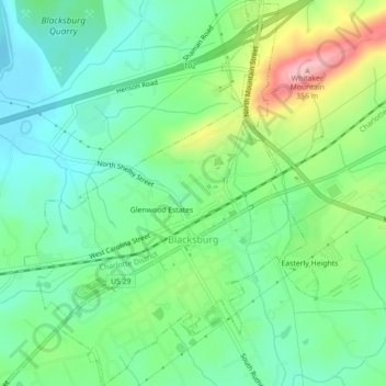
Naam: Topografische kaart Blacksburg, hoogte, reliëf.
Locatie: Blacksburg, Cherokee County, South Carolina, United States (35.10747 -81.53531 35.14359 -81.50160)
Gemiddelde hoogte: 228 m
Minimale hoogte: 171 m
Maximale hoogte: 349 m
Whitaker Mountain is partially in the northern corner of the town, with a summit elevation outside the town limits of approximately 1,169 ft (356 m).
Andere topografische kaarten
Klik op een kaart om zijn topografie, zijn hoogte en zijn reliëf te bekijken.
Maplewood
United States > South Carolina > Cherokee County
Maplewood, Cherokee County, South Carolina, United States
Gemiddelde hoogte: 210 m