
Doe een donatie
Rust jezelf uit voor je volgende avontuur:
Als Amazon-partner verdient deze site een commissie op in aanmerking komende aankopen, zonder extra kosten voor jou.
Topografische kaart South Fulton
Klik op de kaart om de hoogte weer te geven.
Doe een donatie
Rust jezelf uit voor je volgende avontuur:
Als Amazon-partner verdient deze site een commissie op in aanmerking komende aankopen, zonder extra kosten voor jou.
Over deze kaart
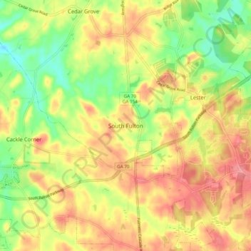
Naam: Topografische kaart South Fulton, hoogte, reliëf.
Locatie: South Fulton, Fulton County, Georgia, United States (33.55027 -84.71123 33.63027 -84.63123)
Gemiddelde hoogte: 272 m
Minimale hoogte: 220 m
Maximale hoogte: 319 m
Doe een donatie
Rust jezelf uit voor je volgende avontuur:
Als Amazon-partner verdient deze site een commissie op in aanmerking komende aankopen, zonder extra kosten voor jou.
Andere topografische kaarten
Klik op een kaart om zijn topografie, zijn hoogte en zijn reliëf te bekijken.
Atlanta
United States > Georgia > Fulton County
Atlanta features a varied topography characterized by its rolling hills and elevated terrain. The city sits at an average elevation of approximately 1,050 feet (320 meters) above sea level, with elevations ranging from about 725 feet (221 meters) to 1,175 feet (358 meters) in the surrounding areas. This…
Gemiddelde hoogte: 284 m
Doe een donatie
Rust jezelf uit voor je volgende avontuur:
Als Amazon-partner verdient deze site een commissie op in aanmerking komende aankopen, zonder extra kosten voor jou.
Johns Creek
United States > Georgia > Fulton County
Johns Creek is located in northeastern Fulton County and is centered at 34°1′44″N 84°11′55″W / 34.02889°N 84.19861°W / 34.02889; -84.19861 (34.0289259, -84.1985790). The elevation ranges from 880 feet (270 m) above sea level along the Chattahoochee River to 1,180 feet (360 m) in the Ocee…
Gemiddelde hoogte: 314 m
Doe een donatie
Rust jezelf uit voor je volgende avontuur:
Als Amazon-partner verdient deze site een commissie op in aanmerking komende aankopen, zonder extra kosten voor jou.
Milton
United States > Georgia > Fulton County
According to the U.S. Census Bureau, the city of Milton has a total area of 39.2 square miles (101.4 km2), of which 38.5 square miles (99.8 km2) is land and 0.62 square miles (1.6 km2), or 1.59%, is water. The elevation ranges from 950 to 1,280 feet (290 to 390 m) above sea level.
Gemiddelde hoogte: 330 m
Doe een donatie
Rust jezelf uit voor je volgende avontuur:
Als Amazon-partner verdient deze site een commissie op in aanmerking komende aankopen, zonder extra kosten voor jou.
Doe een donatie
Rust jezelf uit voor je volgende avontuur:
Als Amazon-partner verdient deze site een commissie op in aanmerking komende aankopen, zonder extra kosten voor jou.
Atlanta
United States > Georgia > Fulton County
Atlanta (/ætˈlæn(t)ə/ at-LAN-(t)ə) is the capital and most populous city in the U.S. state of Georgia. It is the seat of Fulton County, and a portion of the city extends into neighboring DeKalb County. While not included in city limits, unincorporated areas that carry an Atlanta address spill into…
Gemiddelde hoogte: 284 m
Doe een donatie
Rust jezelf uit voor je volgende avontuur:
Als Amazon-partner verdient deze site een commissie op in aanmerking komende aankopen, zonder extra kosten voor jou.
Atlanta
United States > Georgia > Fulton County
Atlanta (/ætˈlæntə/ at-LAN-tə, or /ætˈlænə/ at-LAN-ə) is the capital and most populous city of the U.S. state of Georgia. It is the seat of Fulton County, although a portion of the city extends into neighboring DeKalb County. With a population of 498,715 living within the city limits, Atlanta is the…
Gemiddelde hoogte: 284 m
Atlanta
United States > Georgia > Fulton County
Atlanta (/ætˈlæntə/ at-LAN-tə) is the capital and most populous city of the U.S. state of Georgia. It is the seat of Fulton County, the most populous county in Georgia, although a portion of the city extends into neighboring DeKalb county. With a population of 498,715 living within the city limits, it is…
Gemiddelde hoogte: 284 m
Atlanta
United States > Georgia > Fulton County
Atlanta (/ætˈlæn(t)ə/ at-LAN-(t)ə) is the capital and most populous city in the U.S. state of Georgia. It is the seat of Fulton County, and a portion of the city extends into neighboring DeKalb County. With a population of 498,715 living within the city limits, Atlanta is the eighth most populous city in…
Gemiddelde hoogte: 284 m
Doe een donatie
Rust jezelf uit voor je volgende avontuur:
Als Amazon-partner verdient deze site een commissie op in aanmerking komende aankopen, zonder extra kosten voor jou.
Milton
United States > Georgia > Fulton County
According to the U.S. Census Bureau, the city of Milton has a total area of 39.2 square miles (101.4 km2), of which 38.5 square miles (99.8 km2) is land and 0.62 square miles (1.6 km2), or 1.59%, is water. The elevation ranges from 950 to 1,280 feet (290 to 390 m) above sea level.
Gemiddelde hoogte: 330 m
Doe een donatie
Rust jezelf uit voor je volgende avontuur:
Als Amazon-partner verdient deze site een commissie op in aanmerking komende aankopen, zonder extra kosten voor jou.
Atlanta
United States > Georgia > Fulton County
Atlanta (/ætˈlæntə/ at-LAN-tə) is the capital and most populous city in the U.S. state of Georgia. It is the seat of Fulton County, and a portion of the city extends into neighboring DeKalb County. With a population of 510,823 living within the city limits, Atlanta is the eighth most populous city in the…
Gemiddelde hoogte: 284 m
Atlanta
United States > Georgia > Fulton County
Atlanta (/ætˈlæntə/ at-LAN-tə) is the capital and most populous city in the U.S. state of Georgia. It is the seat of Fulton County, and a portion of the city extends into neighboring DeKalb County. With a population of 510,823 (2023 estimate) living within the city limits, Atlanta is the eighth most…
Gemiddelde hoogte: 284 m
Doe een donatie
Rust jezelf uit voor je volgende avontuur:
Als Amazon-partner verdient deze site een commissie op in aanmerking komende aankopen, zonder extra kosten voor jou.
Johns Creek
United States > Georgia > Fulton County
Johns Creek is located in northeastern Fulton County. The elevation ranges from 880 feet (270 m) above sea level along the Chattahoochee River to 1,180 feet (360 m) in the Ocee area along the Alpharetta border. Johns Creek is bounded to the south by the Chattahoochee River and Gwinnett County, and on the…
Gemiddelde hoogte: 314 m
Doe een donatie
Rust jezelf uit voor je volgende avontuur:
Als Amazon-partner verdient deze site een commissie op in aanmerking komende aankopen, zonder extra kosten voor jou.
Doe een donatie
Rust jezelf uit voor je volgende avontuur:
Als Amazon-partner verdient deze site een commissie op in aanmerking komende aankopen, zonder extra kosten voor jou.
Milton
United States > Georgia > Fulton County
According to the U.S. Census Bureau, the city of Milton has a total area of 39.2 square miles (101.4 km2), of which 38.5 square miles (99.8 km2) is land and 0.62 square miles (1.6 km2), or 1.59%, is water. The elevation ranges from 950 to 1,280 feet (290 to 390 m) above sea level.
Gemiddelde hoogte: 330 m
Doe een donatie
Rust jezelf uit voor je volgende avontuur:
Als Amazon-partner verdient deze site een commissie op in aanmerking komende aankopen, zonder extra kosten voor jou.