
Topografische kaart Wonalancet
Interactieve kaart
Klik op de kaart om de hoogte weer te geven.
Over deze kaart
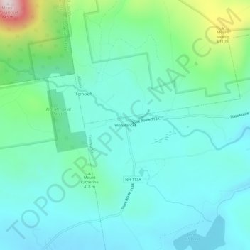
Naam: Topografische kaart Wonalancet, hoogte, reliëf.
Gemiddelde hoogte: 391 m
Minimale hoogte: 275 m
Maximale hoogte: 847 m
Andere topografische kaarten
Klik op een kaart om zijn topografie, zijn hoogte en zijn reliëf te bekijken.
Chocorua
United States > New Hampshire > Carroll County > Tamworth
Chocorua, Tamworth, Carroll County, New Hampshire, 03817, United States
Gemiddelde hoogte: 202 m
South Tamworth
United States > New Hampshire > Carroll County > Tamworth
South Tamworth, Tamworth, Carroll County, New Hampshire, 03883, United States
Gemiddelde hoogte: 265 m